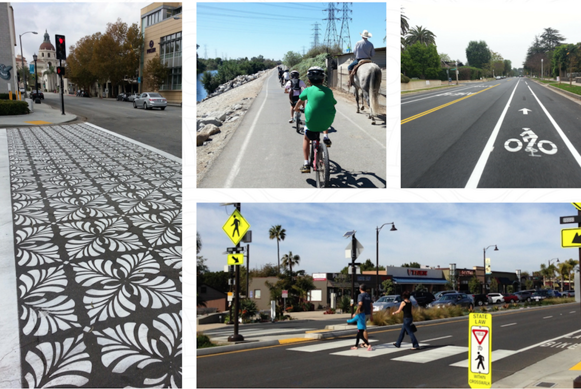
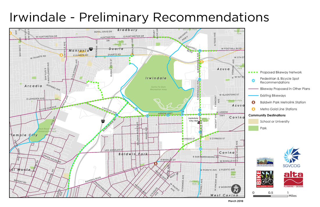
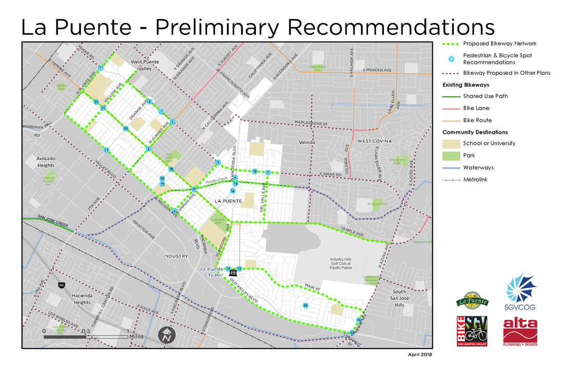
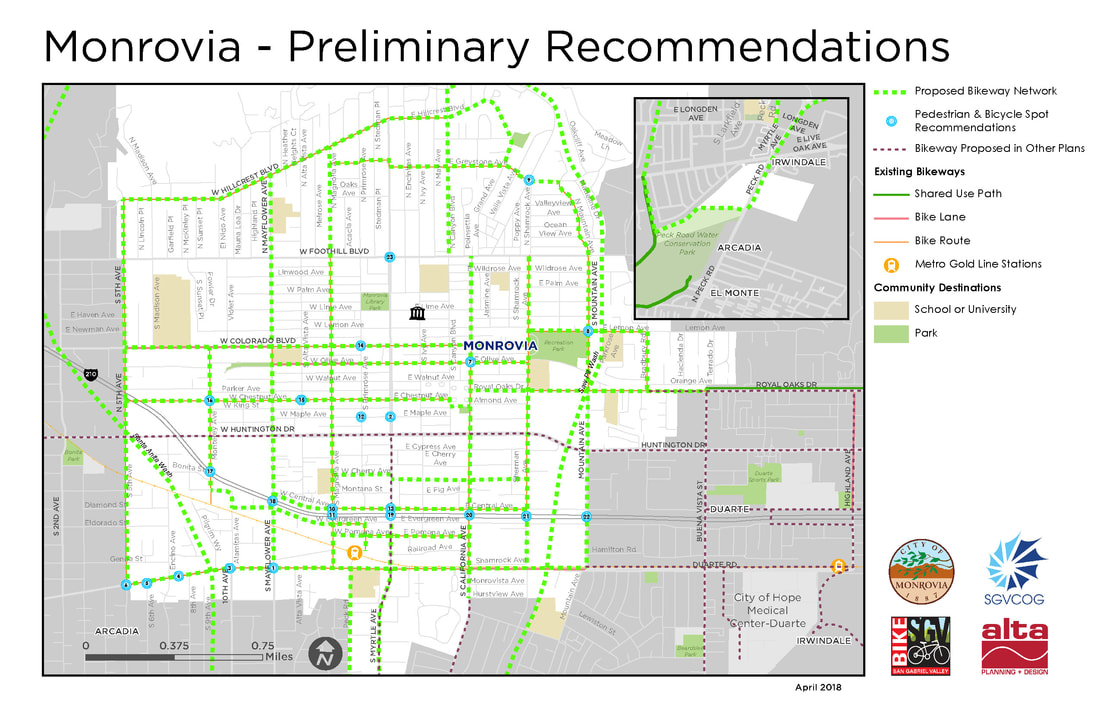
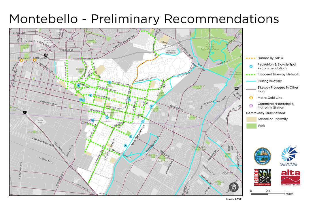
 Sample improvements, clockwise from left to right: High visibility, artistic crosswalk; 'Greenway' multi-use path' Class II Bicycle Lane'; Rapid Rectangular Flash Beacon (RRFB), Pedestrian Safety Island, and High-Visibility Crosswalk Informed by the input received by 748 community survey respondents, 11 public input booths (at least 2 per community), 5 community street audits, and 2 greenway exploratory audits, the #ActiveSGV project team has developed the following draft pedestrian and bicycle plans. Now is YOUR opportunity to review the drafts and provide additional suggestions, recommendations, and feedback. Draft plan maps for the 5 project cities (Glendora, La Puente, Irwindale, Monrovia and Montebello) as well as the SGV Greenways Feasibility Study can be found below. If you would like a high-quality version of any of the maps below, you can download them here. Please take a few minutes to view the maps and recommendations you're most interested in, and then submit this online form if you have any additional feedback. Input deadline is May 31, 2018. Thank you in advance for your time and consideration! 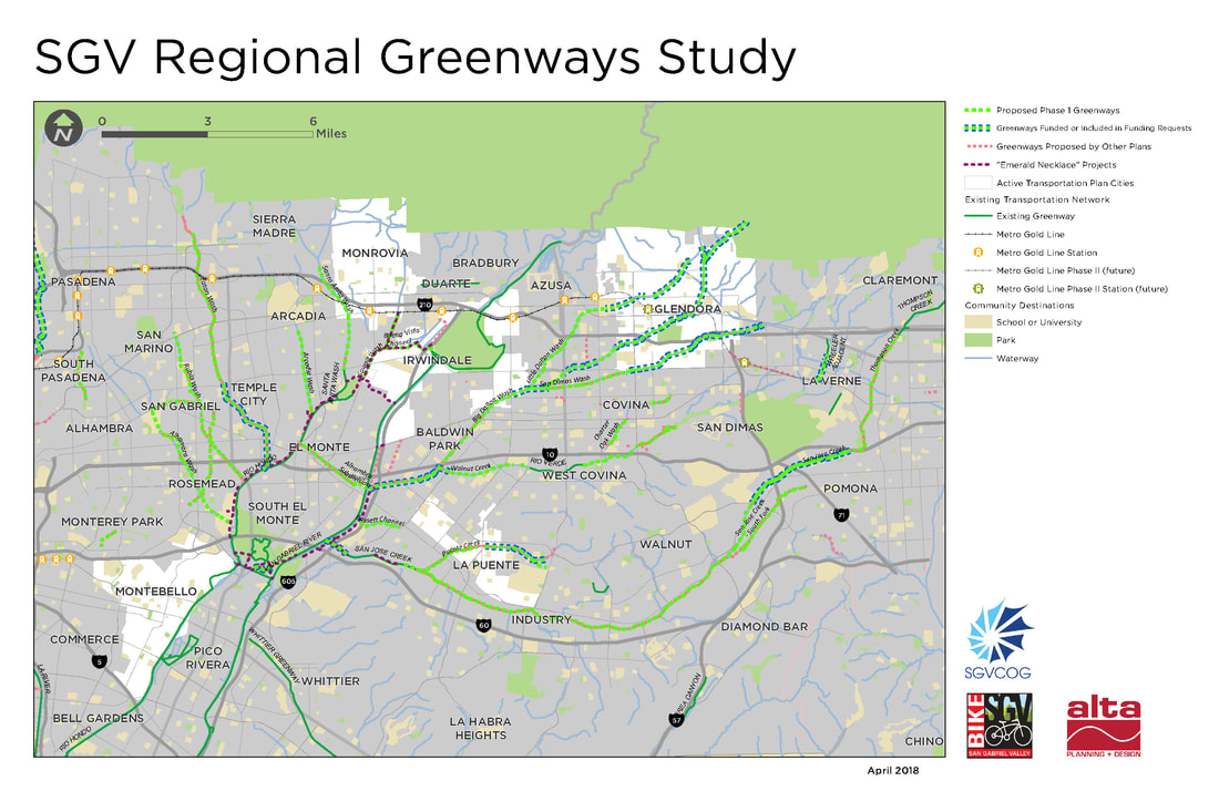 SGV greenways prioritization started with a review of almost 900 miles of Waterway, Utility, Rail, and old Red Car Line alignments. This was reduced to about 220 miles by removing highly constrained corridors and existing segments, and then further reduced to 72 miles by focusing on projects that have undergone previous planning. Analysis methodology generally followed the CA-Active Transportation Program (ATP) scoring:
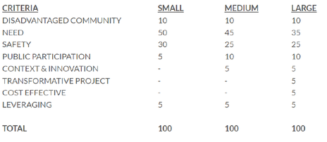 CA-ATP (Cycle 4) Scoring Methodology 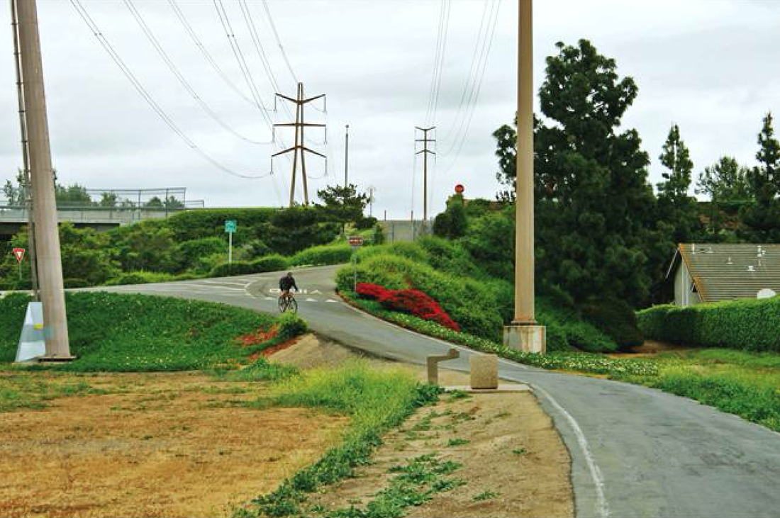 Walnut Trail, Edison Right-of-Way, Irvine, CA Walnut Trail, Edison Right-of-Way, Irvine, CA Waterways Alhambra Wash: 4.2 Miles Cities: Industry (0.5 miles), El Monte (2 miles), San Gabriel (1.5 Miles) The northern end of this corridor is Mission Rd, between San Gabriel High School and Alhambra Golf Course, where a potential connection exists to a proposed greenway along the rail corridor. Moving southward, the corridor passes Vincent Lugo Park then uses an on-street connection across Valley Blvd, then continues along the channel past Del Mar Blvd. The southern end is at the Whittier Narrows Golf Course and Rio Hondo Bike Path. Several undercrossings, including I-10, and a narrow channel make this route challenging. Arcadia Wash: 2.5 Miles Cities: Arcadia (1.3 Miles), El Monte (0.2 Miles), Temple City (0.9 Miles) This corridor begins near Arcadia High School at the north, then heads south to cross existing bike lanes on El Monte Ave. From there it runs parallel to El Monte Ave until its terminus at the Rio Hondo Bike Path. Bassett Channel: 1.3 Miles Cities: City of Industry (0.3 Miles), Unincorporated (1 Mile) From east to west, the corridor follows Workman Mill Rd near Valley Blvd to the San Gabriel River Trail. It must cross I-605 to make the connection to the San Gabriel River on the west, which would require a major undercrossing. The corridor would otherwise end at Packam Dr. Bike lanes on Workman Mill Rd provide an alternate connection via San Jose Creek. Big Dalton Wash: 4 Miles Cities: Baldwin Park (1.9 Miles), Covina (0.4 Miles), Irwindale (0.7 Miles), Unincorporated (0.9 Miles), West Covina (0.3 Miles) This corridor fills in missing gaps in Big Dalton Wash, adding onto previously-funded portions in Glendora, Azusa, and Unincorporated areas. It begins at Barranca Ave at the northeast, and travels southwest to the I-10 where it meets Walnut Creek. The portion of Walnut Creek from this confluence to the San Gabriel River has been previously funded. Buena Vista Channel: 1.8 Miles Cities: Irwindale (1.8 Miles) This corridor begins on the east at the new trail connecting the San Gabriel River path and Duarte Gold Line Station. It follows the channel west to Sawpit Wash. Charter Oak Wash: 1.5 Miles Cities: Covina (1.5 Miles) While this corridor is entirely within the City of Covina, it is in two main segments. At the north it connects from E Cypress St to an existing path in Kahler Russell Park. An on-street connection south on Grand Ave then west on E Badillo St, rejoining the channel and traveling south through residential neighborhoods, crossing E Puente St and E Rowland St to reach E Workman Ave. Eaton Wash: 4.6 Miles Cities: Pasadena (2.1 Miles), Temple City (0.6 Miles), Unincorporated (1.8 Miles) Filling out the northern reach of Eaton Wash, this corridor begins at E Washington Blvd and Woodlyn Rd at the north, running parallel to the utility corridor, south past I-210, where an on-street connection may be needed. The southern terminus is Muscatel Ave, where another planned segment is underway. Little Dalton Wash: 3.3 Miles Cities: Azusa (2 Miles), Unincorporated (1.2 Miles) Beginning at the city limits of Glendora at the north, at Citrus College, Little Dalton Wash moves southwest through Azusa and Unincorporated areas. It passes just north of Azusa High School before intersecting I-210, where the channel will either need to be modified for an undercrossing or an on-street connection will need to be used. The corridor passes three more schools before terminating at the confluence with Big Dalton Wash. Portions within Glendora have already received funding and are excluded from this study. Puente Creek: 2.2 Miles Cities: City of Industry (0.7 Miles), La Puente (0.8 Miles), Unincorporated (0.7 Miles) This corridor begins just west of the shopping center at S Hacienda Blvd and Amar Rd in La Puente. Moving southwest it passes Sparks Middle and Elementary Schools, and crosses a set of railroad tracks between Proctor Rd and Don Julian Rd before meeting San Jose Creek. Rubio Wash: 4.7 Miles Cities: El Monte (0.1 Miles), Rosemead (2.0 Miles), San Gabriel (1.7 Miles), San Marino (0.7 Miles), South El Monte (0.1 Miles), Unincorporated (0.2 Miles) This corridor begins at San Marino High School in the north, and moving south, crosses Huntington Blvd and San Gabriel Country Club. Portions of the channel are blocked with parking lots near Valley Blvd and S Walnut Grove Ave. The channel crosses under I-10 before meeting the west bank of the Rio Hondo. San Dimas Wash: 2.7 Miles Cities: Covina (2.1 Miles), Glendora (0.3 Miles), Unincorporated (0.3 Miles) Closing a gap between a funded portion in Glendora and its confluence with Big Dalton Wash, this corridor follows an existing maintenance road and connects to Hollenbeck Park. San Jose Creek: 16.8 Miles Cities: City of Industry (9.5 Miles), Pomona (5.1 Miles), Unincorporated (2.2 Miles) The longest overall corridor in this study, San Jose Creek largely parallels SR 60 and Metrolink rail. The northeasternmost point connects to Ganesha Park in Pomona, and would require a new underpass or an on-street connection to move south of I-10. The corridor passes several parks and schools before crossing under SR 71 and SR 57, running alongside Cal Poly Pomona before entering City of Industry. A portion at the western end, within City of Industry has received funding, and an unincorporated segment at the furthest west point connects to the San Gabriel River. San Jose Creek – South Fork: 2.6 Miles Cities: Pomona (2.6 Miles) This corridor runs from Veterans Park soccer complex in Pomona, southwest to baseball fields in Diamond Bar, crossing industrial and agricultural areas. Santa Anita Wash: 3.2 Miles Cities: Arcadia (2 Miles), Monrovia (0.8 Miles), Unincorporated (0.4 Miles) Beginning at E Sycamore Ave at the north, near Foothills Middle School, the corridor passes Eisenhower Park before crossing under I-210. Heading south, it crosses relatively few streets before reaching the Rio Hondo Bike Path in Arcadia, at E Live Oak Ave. Sawpit Wash: 2.2 Miles Cities: Irwindale (0.8 Miles), Monrovia (0.4 Miles), Unincorporated (0.9 Miles) This corridor begins in the north at E Duarte Rd near Maxwell Elementary School. It follows the channel south, joining with Buena Vista Channel, terminating at Peck Rd. A connection from the end of Sawpit Wash to the Rio Hondo Bike Path would be made at Peck Rd Park. Thompson Creek: 3 Miles Cities: Claremont (0.6 Miles), Pomona (2.4 Miles) Near Sumner Elementary School in Claremont, the corridor follows existing maintenance roads adjacent to the channel south to Bonita Ave, where it runs parallel to Fulton Rd until reaching the Pomona Fairplex. The southern terminus of the channel can connect to San Jose Creek at Ganesha Park. Walnut Creek: 5.2 Miles Cities: Covina (1.2 Miles), Unincorporated (0.4 Miles), West Covina (3.6 Miles) This corridor’s easternmost point, on N Reeder Ave, south of Badillo Elementary School in Covina, follows a naturalized creek through a neighborhood with limited access. An alternative easternmost point would be at E Covina Hills Rd, where an existing maintenance road follows the channel to I-10, where an undercrossing or on-street connection would be needed. South of I-10, the corridor follows the channel west to meet a previously-funded project in Baldwin Park at Big Dalton Wash. Rail Corridors Alhambra Subdivision (Amtrak Parallel): 4 Miles Cities: City of Industry (0.5 Miles), El Monte (2 Miles), San Gabriel (1.5 Miles) An east-west connection between the Rio Hondo and San Gabriel River Bike Paths is created by this rail corridor in the City of Industry and El Monte. Madrid Middle School lies at the eastern end. Overall the right of way is sufficient to create a trail parallel to existing rail lines, though a crossing at Garvey Ave may require an on-street connection or a new bridge. The portion of the corridor in San Gabriel creates and east-west connection between Alhambra Wash and Rubio Wash, two other proposed greenways. Utility Corridors Edison Right of Way (ROW): Monterey Park, 0.7 Miles Meeting the existing Edison Trails Mark in Monterey Park, this connection runs west then south, terminating at W Floral Dr between Hendricks Ave and Findlay Ave. This trail would require negotiations with existing nursery operations within the utility corridor. Edison ROW: Rosemead, 3 Miles This utility corridor spans nearly the entire San Gabriel Valley north-to-south, and crosses several other potential greenways. The portion under study here, in Rosemead, begins at Grand Ave in the north, crosses I-10, and ends at Graves Ave. Nurseries are currently using portions of the corridor, while other portions are open. Zapopan Park falls in the middle of the corridor. Edison ROW: South Pasadena, 1.3 Miles This corridor runs from Grevelia St and Garfield Park at the north, to W Alhambra Rd and Alhambra Park at the south, with a gap in the middle at South Pasadena Middle School. It passes primarily through residential neighborhoods, and is currently clear of existing uses beyond a maintenance road. 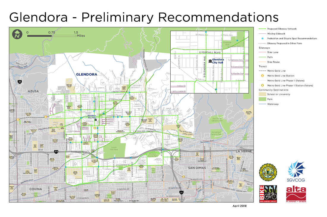 Spot Recommendations (based on community input and feedback)
 Spot Recommendations (based on community input and feedback)
 Spot Recommendations (based on community input and feedback)
 Spot Recommendations (based on community input and feedback)
 Spot Recommendations (based on community input and feedback)
2 Comments
Max
5/14/2018 01:54:05 pm
It's difficult to view the numbers on these maps (and also on the high resolution ones linked). Are there 300DPI versions available?
Max
5/14/2018 01:54:58 pm
Oops nevermind, I didn't see the PDF link before! E.g. http://www.bikesgv.org/uploads/1/0/3/4/10345694/sgv_greenways_preliminary.pdf Leave a Reply. |
Archives
May 2018
Categories |
 RSS Feed
